Tuesday, 17 March 2009
We drove to Billa Bara, a local hill, and parked. It was a nice day but there was a cold wind. We found the Ivanhoe Way and followed the path that we had missed on our last walk. The path went over waste land, then over a disused tramway and finally ran parallel to the road running through Stanton under Bardon. We walked alongside some allotments where every one was starting to get ready for the new season; there were some interesting bird scaring devices on the plots. We crossed a couple of pasture fields which had several rather friendly horses who wanted to investigate the contents of our rucksacks. We had to persuade them to move away from the stile so that we could climb over. We crossed the lane and entered a new section of National Forest called Partings wood, so called because it is midway between Stanton under Bardon and Thornton and was where lovers from the villages parted before returning home.
We walked through more plantations and then along a wide grass path by the side of a large field.
We emerged at the disused railway bridge near to Bagworth. We walked under the bridge and then diagonally across a field and round the bottom of a mound (complete with the first cows we had seen on a walk this year) to emerge at the road in Bagworth. Here we joined the Leicestershire Round. We stopped to search for a geocache in a new plantation and then crossed the railway line. We continued over the bridge at Thornton Mill, which had a lovely display of snowdrops and then walked into Thornton where we stopped for lunch at the Bricklayers Arms.
After lunch we walked along to the reservoir where we searched for another geocache. It was bitterly cold in the wind here. We did a complete lap of the reservoir, stopping to have a cup of coffee in a warm sheltered area. The water appeared to be boiling with the movement of loads of frogs in the water, the ducks were feasting on the spawn. We rejoined the Leicestershire Round for a short distance but left it at Manor plantation and walked through more woodland until we got to Markfield lane. We crossed the lane and crossed more fields until we emerged at the school in Stanton under Bardon. We walked through the village and walked back to the car, passing a big area of gorse giving off a lovely smell of coconut. We had walked 15.5km.
Sunday, 19 October 2008
Leicestershire Round: Ashby Folville to Burrough Hill
Today was bright and sunny so we set off to do the final section of the Leicestershire Round. We parked in Ashby Folville and set off up the road to join the LR. We climbed the stile into the first field to be encountered by a huge bull standing beside the path. He was much more interested in his lunch than us. As we climbed the slope we saw his family, a few cows with very young calves. We continued across the fields and under a bridge over the disused railway line and continued into Thorpe Satchville. There was a lovely church here but it was locked so we couldn't look around. From Thorpe Satchville we followed along Baker Lane towards Burrough on the Hill. We crossed onto a ploughed field and followed the track up the hill to Burrough Hillfort. This was where we had started this walk on 22nd August 2007. We walked along the ramparts to do a complete lap of the fort and then retraced our steps down and back to the Leicestershire Round. We walked across the fields and up to the road leading to Burrough on the Hill. We had a nice lunch in the Stag and Hounds and then left to walk towards Twyford. As we walked along the road a man came out of his house and asked us if we wanted some apples. He picked 4 lovely apples from his tree and gave them to us to munch on the way. They were lovely and sweet and juicy with pink flesh. The field towards Twyford was very difficult as it had been ploughed and was very uneven under foot. From Twyford we walked along the river through lots of fields full of sheep and headed back to Ashby Folville. It felt like quite an achievement to have finished the LR. We walked 15.7 km today and the whole walk had been 392km walked in 28 stages.
Wednesday, 15 October 2008
Leicestershire Round: Gaddesby to Ashby Folville
Monday 29th September 2008
It was a nice day so we decided to do some LR. We had been hoping that this would have been the last section to finish the LR but John has not been feeling too good (he has been having problems with his back and neck again) so we cut the route down to a short one. We parked in Gaddesby and walked down the lane to join the footpath going past the church. The door was open so we went in for a look. It was a lovely light airy church with lots of clover shaped windows. It contained a very large equestrian monument which is supposedly the only one in a church in England.We then continued along the footpath until we joined the LR, where we had last left it. We crossed several fields, one containing some bullocks, but they ignored us. Lots of the fields had been ploughed but they were not too bad to walk over as it was fairly dry. We finally emerged in Ashby Folville. We decided to return here as we didn't want to overdo it. The pub here was closed for renovation and would be opening on Saturday. We thought that was a bit long to wait so decided to walk on to the pub in the next village. We walked alongside the church and then over the fields and along a path through a narrow stretch of woodland and over a stream. We crossed the driveway of a country house and then passed into a field full of cows which were all huddled close to the stile. We bravely walked through the field and managed to get over the stile where we walked into Blaseby. Here we sat on a wall to look at the map and the local postman stopped and told us the way. He was very friendly and looked a little like Billy Bunter! The pub here was now a building site. We carried on walking over fields full of sheep back towards Gaddesby. We finished the walk by passing under a long avenue of oak trees where we found that the pub did not open on Mondays, so it was back to the car for an apple before going home. We only walked 6 km but it was enough.
Sunday, 14 September 2008
Leicestershire Round: Rotherby to Gaddesby.
It was a lovely day so we set off for possibly our penultimate LR walk.
Wednesday, 3 September 2008
Leicestershire Round: Cossington to Rearsby to Rotherby
So I will slip it in here.
Tuesday 22nd July 2008
Leicestershire Round Cossington to Rearsby
The forecast was good so we drove to Cossington to do section of the LR. As we drove through Oaks in Charnwood we only just missed hitting a buzzard that flew in front of the car.
We walked along Bennets Lane in Cossington and over the railway bridge where a trainspotter was standing taking photos of all the trains passing underneath. We then walked along an uninspiring lane which became a track for about a mile.
We walked past Ratcliffe college, a private catholic school and left the lane at a signpost pointing into the school grounds. It seemed a bit strange wandering over their football pitches and wondered what it would have been like during termtime. The exit path was through a small gap in the hedge but the signpost had been knocked down, so we missed it at first; you would have thought that good school security would have wanted strangers sticking to a well signed footpath and not wandering around looking for the way out.
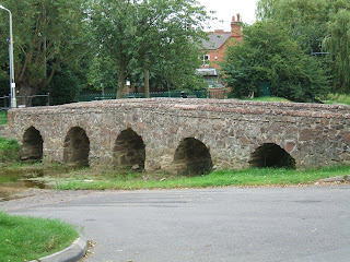
The path led through a field to the busy A46 which we carefully crossed and then walked through a well marked wheatfield and some sheep pasture onto a lane which we followed to Rearsby mill. Past the mill we headed along a green lane through a housing estate and past a nice packhorse bridge where we left the LR.
The footpath emerged onto the road at East Goscote where we crossed over a bridge over the river Wreake where we watched shoals of fish. Further up the road we passed into some woodland beside a golfcourse. The path was very overgrown and although by the river was not pleasant. The path became very narrow and sloping and encroached by nettles and brambles and there was no wildlife on the river. We eventually emerged on the edge of a large wheatfield. Although there were footpath signs there was no way through the field. A lady with a dog told us if we followed the field boundary we would come to a underpass under the A46. We followed round the edge and under the pass into another wheatfield with a path signpost but a very overgrown field boundary. The proper footpath across the field was missing but a wide track had been put in at a different position. This was full of wild wheat which made the track difficult to walk on. We eventually emerged onto a lane which we crossed and into a field of nearly ripe maize with a good path through the middle. We emerged from this field back at Cossington. 14.8km.
Wednesday 20th August 2008
Rearsby to Rotherby
Back from holiday and off for a real walk! We drove to Rearsby, parked and set off over the pack horse bridge. We headed past the church and then across an area of parkland where two men were repointing an ancient wall. As we crossed the next field we came across a sign saying a footbridge beyond was closed. We decided we should have used the footbridge and needed to look for a diversion. We walked on and met a man, walking his dog, who said work had been carried out on the bridge 6 weeks ago and that it should be ok now. The next man we met told us he didn't know if the bridge was open and then proceeded to direct us on walks all around the area but not appreciating we wanted to stay on the LR. He also warned us about the cows in Frisby who like to chase you - not a good sign for our next walk. We decided to walk on and check the bridge for ourselves and retrace our steps if necessary. We came to the bridge and it looked open so we crossed it. Then over the next bridge and round the corner to find the path taped and warning people from that side that the bridge we had just crossed was unsafe! There was no point turning back now and recrossing the "unsafe" bridge so we ducked under the tape and continued our walk.
We walked across fields and eventually arrived at Hoby where we looked around the church. It had a highly decorated and carved rood screen and beautifully painted ceiling arches.
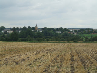
We went into the Blue Bell for lunch and then walked across more fields to Rotherby. Many of the fields have now been harvested but a few still have standing crops of wheat and barley. From Rotherby we walked along the road and across a cattle grid. Whilst walking across this field John startled a hare who raced away from us, and then we attracted the attention of a large herd of bullocks. We spotted the stile and hastened towards it with the bullocks getting more boisterous and snorting. We quickly got over the stile and relaxed while the bullocksgalred at us from the the side of the fence! We walked through Brooksby agricultural college and followed the track through more fields until we arrived back in Rearsby. 12 km.
Monday, 21 July 2008
Leicestershire Round Mountsorrel to Cossington
It was sunshine and showers today so we were off to do a bit more of the Leicestershire Round. We drove to Mountsorrel, parked near the butter cross and headed off towards the LR. We crossed a playground and sports field to a stile which according to our 30 year old guide book led beside a farm but now goes through a housing estate. We followed the LR signs through the estate and then followed a path beside a stream. The official LR path was overgrown and impassable but another path ran on the other side of the stream. Signs suggested an alternative route, but an alternative route to what as there was only 1 route under the A6 and in the opposite direction to the LR. After the underpass we retraced our steps on the other side of the stream and eventually regained the LR - quite a diversion. The path now travelled over fields until we crossed the river Soar at Sileby. The heavens opened here, but luckily we had waterproofs.
We followed the path beside the river spotting lots of butterflies (red admirals) and dragonflies; two herons also past overhead. We eventually arrived at Cossington meadows, an old gravel pit which has been left to return to nature. It was lovely, with large ponds, wild flowers and a wide path mown through the middle. There was lots of wildlife including lapwings, swans and coots. We walked through the meadow and emerged in Cossington. Along the village street were several large oak trees which had been planted to commemorate all the coronations since Edward VII. We had lunch in the Royal Oak and then left the LR to return back to Mountsorrel. As we walked along a lane towards an alternative entrance into the meadows we saw two weasels playing in the road.
We followed a different path back through the meadows to Sileby lock, getting another soaking along the way. Here we continued along the river, which was very busy with motor boats and barges.
The river passed under the A6 and returned to Mountsorrel by another lock. It was a very pleasant walk - good job we had our waterproofs.
Thursday, 17 July 2008
Leicestershire Round - Woodhouse Eaves to Mountsorrel
Today we parked in Woodhouse Eaves to do a celebratory Leicestershire round walk as I have finally finished my radiotherapy. The idea was to just walk to the reservoir and back so I wasn't worn out too much. We set off across a good footpath through a field of corn towards a farm and then across a field with a herd of sleepy cows. We then walked through a field of maize until we got to Bunny bridge over the Great Central Railway. We followed the road to Swithland reservoir where we had originally decided to turn round and retrace our steps, however, we decided to continue the walk to Mountsorrel as we were both feeling ok.
Halfway round the reservoir the heavens opened. We managed to stand in the lea of some trees to shelter until the storm passed (about 20 Minutes) and did not get too wet. When the sun came out we continued walking round the reservoir taking care not to tread on the little froglets that were hopping across the wet road. We did pass a lad slopping along in soaking socks, carrying his dripping shoes - he obviously had not been able to find any shelter.
We crossed the road and continued towards Mountsorrel, walking round a quarry and past the castle mound.
We had lunch at "The Swan" whilst another shower passed and afterwards followed the road towards Mountsorrel Quarry where we lost the path and were shown the correct way by a worker. Apparently the bridleway is shown on the map as going through the middle of their weighbridge building. The diverted path took us around the back of the quarry buildings but was not well marked. We dodged the quarry lorries and eventually found the footpath which passed through woodland, until we came back to the road that goes around Swithland reservoir. We retraced our steps and just missed seeing a steam train pass under Bunny bridge- We saw clouds of steam. We walked back across the fields which were a lot wetter than when we had passed earlier. I was exhausted by the time we got back to the car but was pleased to have made it despite having finished radiotherapy yesterday. We walked 14 km.
Tuesday, 3 June 2008
Leicestershire Round - Newtown Linford to Woodhouse Eaves
Monday, 19 May 2008
Leicestershire Round - Markfield to Newtown Lynford
We did a LR round walk today in training for our sponsored walk for the Kent hospices on Sunday. It was sunny but with a cool breeze. We drove to Markfield and set off along Main street to reach a footpath which took us under the A50, the path then went through woodland parallel to the A50. It came out into a nice field that had been planted as National Forest in 2000 and gave good views of Bradgate park, where we were heading. We then crossed a large field towards a wood which was filled with bluebells -it was a lovely sea of blue. More National Forest and horse paddocks followed until we reached Newtown Lynford.
We stopped here for some lunch - we were a bit early but sat and waited for the pub to open. We had a nice break out of the sun and then set off again.
We followed the footpath towards the back of Bradgate park where there were lots of people flying kites. Unfortunately the path marked on the map turned out not to be a footpath so we had to alter our route and continue through the park and onto the road. The woods we had planned to walk through also had no public access so we had to walk along the road and find an alternative footpath. We eventually rejoined the LR where we saw a little yellow frog hopping through the grass. After a short stretch retracing our steps, we diverted off onto a different footpath to follow a different return route which brought us to Field Head where we crossed the A50 and returned to Markfield.
The terrain in the last sections of the LR has definitely been new woodland. Leicestershire used to be known as the greenest county in England but with the fewest trees and least access. This has definitely changed with the advent of the National Forest. This area would until recently been full of coal mines and quarries and it is now turning into lovely native woodland. We walked about 7.5 miles.
Monday, 12 May 2008
Leicestershire Round -Thornton to Markfield
Hooray -my chemotherapy is finished and hopefully I can now get back to some decent walking.
We started off by doing a bit more of the Leicestershire Round.
We drove to Thornton, by an interesting route as John was not paying attention! We parked near the pub and set off along the LR and skirted across the top of Thornton reservoir, although the GPS said we were wading through the middle. We then walked through lots of National Forest plantations, mostly planted in 2000 so they were maturing nicely and a great improvement on the spoil tips and coal mines that would have been here before.
We arrived in Markfield and had a drink and bag of crisps at the Bulls Head, where the locals were playing dominos. We then left the LR and walked along lanes and overgrown footpaths towards Cliffe Quarry. We walked around the quarry but did not see any workings although an information board did explain all the geology of the area. There was a lot of gorse in flower on the hills and it was giving off a strong smell of coconut. We walked through Stanton under Bardon behind the houses and then crossed into a field with some cows who were interested but well behaved but a small yappy dog was among them and came charging at us barking furiously.
John eventually roared at it which sent it scarpering away.
We crossed into more National Forest plantations and walked parellel to the same field only to see at the top of the field an enormous bull surrounded by his ladies. I was glad I was now on the other side of the fence.
We continued walking through the plantation to the sound of cuckoos (nothing like yours Judith!!). We finally had to cross a very large field of oil seed rape. Luckily the farmer had cut a good footpath through the middle as it was about 1.5m tall, in full flower and very strongly smelling.
We finally got back to Thornton in time for a welcome drink at the Bricklayers Arms. The walk was only 6.5 miles but had felt much longer as it had been so hot.
Wednesday, 9 April 2008
Leicestershire Round - Nailstone to Thornton
We did a Leicestershire Round walk today. We had originally planned to walk to Thornton but following our colds and lack of walking we thought we might cut it short at Bagworth. We parked at Nailstone and followed the path to Bagworth. This had been coalmining country and our 25 year old guide book warned us about the spoil heaps and quarrying, but the pits had closed and the land is now reclaimed and planted with trees as part of the new National Forest. We arrived in Bagworth quite quickly but could not see anywhere to stop for lunch so decided to walk on to Thornton on our original planned route. We had lunch in the Bricklayers arms which we had visited a few weeks ago. The same group of old men were in there putting the world to rights and discussing the old railways through Bagworth and the history of the Swannington incline which was quite interesting. We walked on after lunch and lost our way a bit around the Thornton brick works but eventually found the route passing by some fishing lakes. We came out onto the road to Barleston and were stopped by a chap who asked us if we were heading onto the footpath across his land. He had had a run-in with gypsies that morning who had been stealing stuff from his stables. He had had stiches and was still bleeding from the assault. He said he had cameras filming so we might be filmed. He spoke to us for quite a while telling us tales of shooting arrows at night and jogging across his land naked carrying an axe to cut down a tree in the early morning and wondering why the birdwatcher ran off leaving all his equipment behind! We had quite a laugh, I think he was a still shaken from his experiences that morning and wanted someone to talk to. He said if we were back that way in the summer to call in for a glass of wine! We continued across the fields towards Barlestone and along a river bank and then set off on a footpath back to Nailstone.
We were stopped by another local who told us we had missed the footpath and pointed out the correct way. He stood chatting to us for about 15 minutes telling us about all the local walks. We finished off the walk and got back to Nailstone at about 5.30 after 16 km. So much for a shortened walk but it was nice having chatted to so many friendly locals.
Sunday, 27 January 2008
Leicestershire Round:Shackerstone to Nailstone
Despite having had my first course of chemotherapy last week I felt fit and fine and as the weather was ok we went for a walk. We drove to Shakerstone and parked near the pub and set off under the railway bridge where we could see shunting engines moving trains around on the Battlefield line. The paths across the fields were beautifully marked and were firm underfoot which was surprising considering the amount of rain we had had recently. We walked past Odstone Hall and then continued on towards Nailstone. We stopped on the way to do "Odstone Out" - a geocache, which we found easily. In Nailstone the pub was closed so we sat and had a cup of coffee and a biscuit in the churchyard. The church was also closed. We left the Leicestershire Round and started our return walk. On the way we past a pub, so called in for a drink and bag of crisps -purely medicinal to keep my fluids up. The next field had been completely enclosed with electric tape, blocking off all the stiles but it wasn't live so we ducked under and followed the footpath to reach the road to Carlton where we took the footpath to Barton in the Beans. The first field here was exceptionally, ankle deep muddy (possibly cow slurry-but we don't like to think of that -John will clean the boots later!), but we got across and followed the footpath, stopping to do Birthday Surprise -another geocache. We finished our walk along the very muddy bridalway back to Shakerstone having walked about 13km. This walk was all across old coal mining areas but there were no signs of slag heaps or mining industry anywhere much of it being converted into the New National Forest.
Sunday, 13 January 2008
Leicestershire Round: Market Bosworth to Shackerstone
The first bright day for a while and the only one forecast for a while so we made the best of it and did a bit of the Leicestershire Round- we are now about 2/3rds of the way round.
We parked at Market Bosworth Park and walked through the town and along a lane to join the footpath. The path went past some lovely houses, all with balconies to make the most of the views although it looks as though the views may be disappearing as a lot of the land had been excavated for what looks like a road and a housing development. After a short diversion along the wrong footpath we continued across fields to Carlton. At one place the footpath was under about 6 inches of fast flowing water which we waded through, only getting the tops of the socks wet, thanks to our gaiters, and continued through the very muddy field.
Although the fields were muddy we did not have to go across any ploughed areas so it was not as difficult as last weeks walk.
After Carlton we crossed more fields to arrive at the Shackerstone Railway. This is a tourist railway known as the Battlefield line. There were no trains running today but the Victorian Station was open so we had a look around.
We crossed the Ashby canal at Shackerstone and stopped at the Rising Sun for lunch which was a lovely pub –very warm and cosy, and good food.
When we eventually pulled ourselves away from the pub we returned to Market Bosworth along the Ashby canal. We got back to the car just as it was getting dark after walking 14.2km.
Monday, 7 January 2008
Leicestershire Round:Dadlington to Market Bosworth
It was a bit brighter today so we went for the first real walk of the New Year. We parked at Cheyney Wharf by the Ashby Canal to do the next bit of the Leicestershire Round.
We walked along the canal towpath for a short while before walking through Albion Wood to Bosworth battlefield. At the battlefield we had a short diversion off the route to look for a geocache which we found it near King Richards Well where Richard III drank before the battle against Henry Tudor.
We walked back past the visitor centre and across fields to Sutton Cheyney. The church here was very plain from the outside but inside was quite ornate with memorials to Richard III who fell at Bosworth. We continued through woods to Bosworth Park stopping to do another geocache on the way. The paths were very muddy and it was hard work walking, two steps forward and sliding one step back. We eventually arrived at Market Bosworth and diverted off to have lunch in Ye Olde Red Lion which was a very nice cosy pub. After lunch we looked around Market Bosworth which was small but had some nice shops. We then left the Leicestershire Round and continued our walk going down the other side of Bosworth Park and then crossing more very muddy fields planted with oilseed rape. The footpaths had not been marked so in a few months these paths will be very difficult to walk. We walked back through Sutton Cheyney, using different paths. We then walked towards Daddlington so that we join up our sections of the Leicestershire Round. It was getting dark by the time we rejoined the Leicestershire Round. We did the last mile along the towpath after sunset looking at all the barges and houseboats with names like Chucklebutty, Tin Hatters and Beardlets Billet. We got back to the car at 4.30pm after a good walk even though it was very muddy. It was 15.7 km and there were no cows or horses -just a sheep with a cough!
Friday, 21 December 2007
Leicestershire Round:Burbage to Dadlington
It was cold, frosty and foggy but we decided on a LR walk. We drove to Burbage country park, although there was a bit of a problem as they have moved the A47! I directed us to the A47 which is now a bypass. We found the right road eventually. It was -2 as we got ready. We set off along the LR. It was all very crisp, and the trees were lovely.
It did not feel cold once we were walking. A heron and then a bullfinch and greenfinch flew across in front of us. We walked through Barwell which was a bit industrial and then along more lanes and fields. It was very foggy so there were no views. We crept across one field with cows in, hoping that they wouldn't see us in the fog, but they spotted us when we were about 100m from the stile and decided to investigate. I just about beat them to the stile. We saw a flock of goldfinches in the next field. We walked along a stream until we came to the road at Dadlington. We left the LR here and went to the Dog and Hedgehog for lunch. As we walked back it was a little warmer as all the frost had melted but we were walking into the wind so it felt colder. We also had to cross several planted fields which were very muddy and we ended up with very heavy boots. As we crossed one field we were approached by two friendly donkeys, and then by a third who rushed at us braying very loudly. They were very friendly - from the other side of the stile!
We got back to the car at about 4pm after 15 km walk.
Leicestershire Round:Aston Flamville to Burbage
We decided on a walk as it was bright and clear but frosty. We drove to Aston Flamville to continue our LR. We drove round the village looking for somewhere to park but encountered a very abusive villager who threatened to scratch the car if we left it in the road opposite his house! We decided we couldn't cope with the hassle and so drove on and found somewhere to park in Burbage. We walked back to Aston to start the walk (about a km) and John could not remember locking the car so we had to walk back, check the car which was locked, and then back to the start again. We walked along the side of the M69 for a while and then cut across fields including one with 3 llamas, and then lots of bullocks. It was quite hard underfoot where it was frozen but very wet and muddy where it wasn't. We eventually got to Burbage woods where a heron flew across and then a bullfinch.
We crossed Burbage common to the road and then left the LR. We walked back across the golf course and followed the path back to Burbage. The walk was quite interesting as the council had been painting all the footpath signs so although they were all visible all the pointers had been removed so there were no direction arrows and you didn't know if it was a junction of 2 paths or not. We walked about 11 km.
Thursday, 6 December 2007
Leicestershire Round:Sharnford to Aston Flamville
We have had a bit of an enforced setback on the walking front but decided today to see how I would manage a short walk. We drove to Sharnford to do a shortened section of the LR. It was all across fields and just as we started a heron flew in front of us and landed in the next field. We then walked through a field with some very friendly horses, one of which stood in the gateway and wouldn't move, John spoke to it and it eventually let us pass. We went past Aston Flamville and up to the M69 where we passed a field of Alpacas.
We left the LR here having only walked about 2 mile and walked through the alpaca field and back to Aston Flamville. We had planned a diversion off the road but there were two very excitable rottweillers behind a gate but they had knocked down part of the fencing keeping them in and I thought they could get out if they really wanted and I was not prepared to give them reason to try so we kept to the road. We continued back to Sharnford where we went into the Countryman and had gammon steak for lunch a walk of about 6 km that showed I was ok for walking. Hopefully will get back to some longer ones soon.
Wednesday, 7 November 2007
Leicestershire Round:Claybrook Parva to Shenton
Leicestershire Round:Leire to Claybrook Parva
We drove to Leire to do part 10 of the LR. We walked along the footpath and diverted off to have another look for the cache but we still didn't find it. The LR went across fields, some ploughed, others pasture and then on the lane to Frolesworth, where we had planned to have lunch but the pub had disappeared under a housing development. We followed more fields including one that had signs up saying we were on the edge of the bluetongue protection zone. We eventually got to Claybrook Parva where we left the LR. We followed the road to Ullesthorpe where we had a late lunch and then walked past the windmill which is being renovated and across the golf course which ran beside the disused railway. The path eventually moved onto the railway and we followed the permissive path along the cutting back to Leire. Only a short walk today, 12.1 km.
Sunday, 21 October 2007
Leicestershire Round:Willoughby Waterleys to Leire
The one where John becomes a cowboy.....
It was a lovely day so we decided to do part 8 of the LR walk starting at Willoughby Waterleys. The route is getting ever closer to home as we went even less distance round the ring road. We set off across fields, the first of which had curious bullocks in who decised to follow us, but they stopped when John turned round and stared at them. As we crossed the field we met a girl with two dogs who was a bit wary of how the cows might react to her dogs (hopefully she got through them OK). We walked across lots of fields and beside a very nice fishing lake until eventually we had to cross the M1, another sign we are getting closer to home and moving round the county. After this it was across more fields and past a lake and mill house to Leire. We stopped for lunch here, a bit expensive and not wonderfully cooked. We then diverted from the walk to find a geocache. This involved a walk along a disused railway which has been changed into a nature trail. Some rangers were working there killing some tree stumps to provide more light for wild flowers. We had quite a chat as he told us about the railway and the drainage problems they were having. We found the place for the cache but could not find it although there were signs of damage to the wall where people had been hunting - a shame as the hider had said there was no need to remove stones. So after 10 minutes hunting we gave up and continued our walk. We walked along a path to a stables where an old man hobbling about with a walking stick was trying to persuade a very large horse to go into his stable. We helped direct the horse to the door but he would then just walk past. The horse had escaped the night before and had damaged its leg so was bandaged up. We tried enticing him in with hay and apples but he wasn't interested. Eventually John managed to get his halter on, albeit upside down, and the horse was led back to the stable. The old man was very grateful. We then continued our walk across fields and back across the M1 to rejoin a short section of the LR back to the car. All the bullocks in the first field had gone which was a relief. It was later than we expected (5.30) due to the delay with William the horse and was dusky (17km).