Thursday 27 November 2008

Ivanhoe Way - Moira to Ashby de la Zouch

Saturday 22nd November 2008
It was cold but bright so we set off to do an Ivanhoe Way walk. We drove to Moira and looked for the carpark marked on the map. We found it but it had been closed for some time - looking at the pile of rubble behind the barriers so we parked in the layby. We walked along the road and found the Ivanhoe way signpost pointing across some grassland on a path which had been very churned up by heavy machinery. It was very wet and boggy and I had forgotten to put on my gaiters - wet trousers then! The path crossed new woodland and beside a lake and then crossed several small fields with horses and then newly planted fields which were very muddy. Our boots were very heavy when we left the field. The Ivanhoe Way now passed along the road and into Ashby de la Zouch. This was a pleasant market town where we stopped for a light lunch. We then walked up to look at Ashby castle. Despite having lived within 5 miles of Ashby for 16 years, we had never seen the castle before. We were surprised at how much of the ruins were still there. The castle is not visible as you drive through the town.

Our route then became a bit boring as it was mainly road walking. We headed out of town on the Measham road admiring all the large houses along the way. We crossed the M42 roundabout and turned along the road towards Willesley where we crossed a bridge over the M42 and then walked beside Willesley golf course. We diverted off the lane and walked towards Willesley church and the scout camp. The church was abandoned and had been bought by the scouts for £10. Whilst we were looking for a geocache two men came over and asked if we had found what we were looking for. We explained geocaching to them and then asked about the church. One offered to show us round, so we had a good look at the windows, memorials and the tombstones to members of the Abney Hastings family dating from the 12th century.
It was very interesting and was the high point of a mostly road based walk. It was getting late when we left the church so we followed the footpath to find another cache and then walked back to the car just as the sun was setting. We had walked 13.2km.

Friday 21 November 2008

Ivanhoe Way - Oakthorpe to Moira

Tuesday 18th November 2008
It was forecast to be dry so we went off for a walk. We parked in Oakthorpe and set off along the Ashby wolds trail which is part of the Ivanhoe way. It was very Autumny - lots of leaves but bright and sunny. We last walked this trail on 8th June when it was full of wild flowers. Now it is a bit bleak but still interesting.
We followed the trail to Donisthorpe where we stopped to look for the "Church View" geocache. We tried to look round the church but it was locked. We diverted off the Ivanhoe way to go and look for the "Sword of Merlin" geocache. We walked through Donisthorpe and then across a field full of sheep and across a stream with no bridge but a piece of wobbly corrugated iron to walk on. We didn't get too wet! We continued along another field edge and then through a patch of nice woodland along an embankment. We searched for the cache for a while and eventually found it. Unfortunately, while replacing the cache, my flask fell out of my rucksack and rolled down the embankment. John nobley found a way down and reclaimed it. We retraced our steps to Donisthorpe and continued on the Ivanhoe way through Donisthorpe coliery nature reserve and on to Moira. We emerged on a path above the lime kilns and then onto the canal towpath by Moira furnace. We stopped at the café for some lunch and then crossed the canal and walked through woodland and out onto the road near Norris Hill. We turned off this road and walked down the road towards Willesley. This was a bit of tedious road walking but it did have lots of new plantations on either side.
At the bottom of the road we crossed into woodland. The tracks were very boggy and wet but the trees were nice. We sat by a lake and had a cup of coffee and then continued deeper into the woods where we found the "Heart of the National Forest" geocache.
The path continued alongside a lake, actually it was in the lake in places so we had to divert inland a bit. This path eventually emerged onto the road at Oakthorpe where we followed back to the car. 13.5 km.

Thursday 20 November 2008

Ivanhoe Way, Snarestone to Oakthorpe

Wednesday 12th November 2008
As this was the only forecast dry day this week we had to take advantage. We drove to Snarestone and parked opposite the school so that we could do the next stage of the Ivanhoe way.
We headed across the playing fields and out onto the road towards Measham. This was a bit of a boring trudge along the busy road for about 1 mile. We then left the road and joined the Ivanhoe way around the perimeter of the Hanson brickworks, the path was very slippery but well marked. Behind the brick works we diverted onto a path through a nature reserve which turned into a disused railway line which came out near the old Measham station. This is supposedly being converted into a museum but was still currently deserted. We walked through Measham millenium garden, past a large mosaic sundial, where an alsatian that wasn't on a lead seemed to take a dislike to me. His elderly owner shouted at him but he ignored him. I think it might have been my walking pole that he disliked!


We emerged onto Measham High street and crossed to the Ashby wolds trail. We had walked some of this before. It is a disused railway which has been converted into a cycle path between Measham and Moira.
We left the trail at Oakthorpe by a large mining wheel and followed the road into the village. We saw a flock of bullfinches in a tree by the road.
We left the village and diverted across fields and into Saltersford Valley Park to find a geocache (Kermite Revenge). John saw a kingfisher on the flash pond but I missed it, but we did see coots, grebes, seagull and ducks. After finding the cache we retraced our steps to Oakthorpe to find somewhere for lunch. The Holly Bush was closed at lunchtimes but the Shoulder of Mutton was open, so we had a baguette and a pint. It was ok but not very inspiring. When we continued the walk we passed the Gate Inn which was also closed, so a village with 3 pubs had only 1 open. This is something we are finding very often when we walk. Pubs are either closed at lunchtime or converted into Indian or Chinese restaurants. We walked across a field and then through a farm which was basically a junk-yard, it was full of piles of refrigerators, radiators and other scrap. We had to be very careful walking across as stuff was hidden in the slurry. We eventually found our way out of the yard and onto a footpath which was only about 20m from the path going behind the brick works that we had taken on the way into Measham. We stopped for coffee overlooking a field of cows and then crossed over the field and out onto the Measham Road. We then crossed more fields and then entered what looked like another junk tip as there were several scrapped cars abondoned, they were all sporty expensive cars that looked like they had been involved in accidents. Walking on we came across two military tanks and realised that the area must have been a driving assault course with the cars as obstacles. We walked along a green lane which emerged onto the road leading to Snarestone. We left the road on a footpath through the woods and then behind some very nice large houses and onto a railway embankment. The path deteriorated into a very muddy path which took us back to Snarestone. We had walked 14.7 km.

Monday 10 November 2008

Ivanhoe Way -Shackerstone to Snarestone


Friday 8th November 2008
After what seemed like weeks of dull, dingy, drizzly weather, it promised to be fine today and so we decided on a proper walk. Having finished the Leicestershire Round a few weeks ago, we now embark on our next project, the Ivanhoe Way - a 35 mile walk around NW Leicestershire.

We drove to Shackerstone and parked. This is home to the Battlefield line which runs from Shackerstone to Shenton and is also where the Leicestershire Round joins the Ivanhoe Way.

We set off towards the Ashby canal and headed along the towpath.
Ashby canal carried coal from the pits in Moira and Measham. It closed in 1846 but there are plans to re-open it along the stretch to Ashby.
We saw a heron take off in front of us and several ducks splashing about in the water. We also heard the whump-whump of swans taking off. The canal was very autumnal with leaves falling from the trees into the water. We left the canal at bridge 54 and took the footpath towards Newton Burgoland, but soon left the path and joined the narrow road towards Snarestone. We passed a large house with crowns on the gate and later discovered this was part of Gopsal park which is owned by the Crown. We left the lane just past Shackerstone Fields farm and then crossed several fields to arrive in Snarestone. One of the fields contained a maize crop which had not been harvested. It looked a bit sorry but had lots of cobs, so we wondered why it had been left. At Snarestone we walked to The Globe which although it was 12.15 appeared to be closed. As it was early we decided to continue the walk and try the pub in a later village.

We left the Ivanhoe Way and walked down a footpath between houses and into a field of sheep. The ram was particularly interested and was starting to come closer as we got to the stile (all his ladies had run in the opposite direction). We continued through large areas of National Forest. These plantations of small sapplings, did not seem to be very diverse as the majority of the trees were oak. As the latest fungal disease to hit oak trees has been sighted in Leicestershire it seems a bit short-sighted to have an almost mono-culture. We climbed the hill towards the church at Swepstone and then headed down the road towards Newton Burgoland. The fields here were particularly wet and boggy and we had to cross a large field full of charolais? bullocks. They had a look at us but then continued grazing. We arrived at Newton Burgoland and diverted off to the Belper Arms for lunch- a baguette and very good glass of Hobgoblin. We didn't want to leave as it was so warm and cosy but it was getting late so reluctantly we set off to walk the last 2 km. We followed a footpath past a large pond with lots of geese - possibly being prepared for christmas, and then through a field of dairy cows, through the very boggy area beside the stile and out onto the very muddy lane towards Shackerstone. We got back to the car at about 3.30pm having walked about 13.5 km.

Sunday 19 October 2008

Leicestershire Round: Ashby Folville to Burrough Hill

Saturday 18th October 2008
Today was bright and sunny so we set off to do the final section of the Leicestershire Round. We parked in Ashby Folville and set off up the road to join the LR. We climbed the stile into the first field to be encountered by a huge bull standing beside the path. He was much more interested in his lunch than us. As we climbed the slope we saw his family, a few cows with very young calves. We continued across the fields and under a bridge over the disused railway line and continued into Thorpe Satchville. There was a lovely church here but it was locked so we couldn't look around. From Thorpe Satchville we followed along Baker Lane towards Burrough on the Hill. We crossed onto a ploughed field and followed the track up the hill to Burrough Hillfort. This was where we had started this walk on 22nd August 2007. We walked along the ramparts to do a complete lap of the fort and then retraced our steps down and back to the Leicestershire Round. We walked across the fields and up to the road leading to Burrough on the Hill. We had a nice lunch in the Stag and Hounds and then left to walk towards Twyford. As we walked along the road a man came out of his house and asked us if we wanted some apples. He picked 4 lovely apples from his tree and gave them to us to munch on the way. They were lovely and sweet and juicy with pink flesh. The field towards Twyford was very difficult as it had been ploughed and was very uneven under foot. From Twyford we walked along the river through lots of fields full of sheep and headed back to Ashby Folville. It felt like quite an achievement to have finished the LR. We walked 15.7 km today and the whole walk had been 392km walked in 28 stages.

Linton, Derbyshire, From Beer to Eternity cache walk

Thursday 16th October 2008
We drove to Linton, just inside Derbyshire to do a walk and hunt for a series of geocaches based on Breweries. We parked near Bee Hive fishing lakes and set off for our walk. The first cache was found as we reached the first stile for our walk. We climbed the stile into a field which had only just been planted with rape plants. The footpath had not been reinstated but there was the beginning of a trail of footprints so we followed that across several fields to the edge of a patch of woodland. The stile here was in a dangerous condition and collapsed as we tried to climb over. Luckily there was a very stiff and heavy gate next to it so we were able to continue. We walked beside some farm buildings with lots of large containers outside. We saw that each one had a run attached and contained a young calf. We continued walking through several new areas of National Forest. Top wood and Potters wood were quite advanced, with the trees being about 10 years old. We sat for a while beside a trig point on the top of the hill where we had a snack and then diverted off from the walk to find a cache. The diversion was very wet and the fields were squelchy but we found the cache and retraced our steps back to our route. We continued walking through the woodland which was lovely –it was a bright sunny day, with just a bit of a chill wind, and the colours of the trees were wonderful, especially the spindle trees with their bright pink berries. We finished the walk alongside the fishing lakes as we approached the car park. We had found 13 caches along the way and had walked 13 km.

Wednesday 15 October 2008

Leicestershire Round: Gaddesby to Ashby Folville


Monday 29th September 2008
It was a nice day so we decided to do some LR. We had been hoping that this would have been the last section to finish the LR but John has not been feeling too good (he has been having problems with his back and neck again) so we cut the route down to a short one. We parked in Gaddesby and walked down the lane to join the footpath going past the church. The door was open so we went in for a look. It was a lovely light airy church with lots of clover shaped windows. It contained a very large equestrian monument which is supposedly the only one in a church in England.


We then continued along the footpath until we joined the LR, where we had last left it. We crossed several fields, one containing some bullocks, but they ignored us. Lots of the fields had been ploughed but they were not too bad to walk over as it was fairly dry. We finally emerged in Ashby Folville. We decided to return here as we didn't want to overdo it. The pub here was closed for renovation and would be opening on Saturday. We thought that was a bit long to wait so decided to walk on to the pub in the next village. We walked alongside the church and then over the fields and along a path through a narrow stretch of woodland and over a stream. We crossed the driveway of a country house and then passed into a field full of cows which were all huddled close to the stile. We bravely walked through the field and managed to get over the stile where we walked into Blaseby. Here we sat on a wall to look at the map and the local postman stopped and told us the way. He was very friendly and looked a little like Billy Bunter! The pub here was now a building site. We carried on walking over fields full of sheep back towards Gaddesby. We finished the walk by passing under a long avenue of oak trees where we found that the pub did not open on Mondays, so it was back to the car for an apple before going home. We only walked 6 km but it was enough.

Sunday 14 September 2008

Abbot's Bromley Horn Dance

Thursday 4th September to Tuesday 8th September


Several years ago we did a walk around the area of Abbots Bromley and on visiting the church and pub we discovered the Horn Dance. We promised ourselves that we would return one year to see this annual event.
http://www.abbotsbromley.com/horn_dance

Having noticed that the Folk Dance and Song group of the Camping and Caravanning Club were holding a rally to coincide with this event we hitched up the caravan and set off to join them at Little Dunstall farm.

It was pouring with rain when we arrived but after a warm welcome from the other caravanners who had already arrived we set up the caravan and then when the sun came out we set off for a walk around Blithfield reservoir.

That was almost the last of the sun for the next few days as it poured with rain on Friday, Saturday and sunday morning. We did attempt a walk along the canals at Great heyward but after a few miles the heavens opened again and we abandoned the walk.

On sunday afternoon it dried up a little and we went for a short walk on Cannock Chase. It was very pleasant but from the top of the hills we could see how flooded the surrounding area was following the rain on the previous days. The Trent had burst its banks and several roads were closed.

On the morning of the Horn Dance (the first Monday following the First Sunday after the 4th September) my alarm did not go off but we woke at 6.20 and quickly got dressed and left to walk to Abbot's Bromley. We arrived just in time for Holy Communion and at 7.30 the villagers arrived to collect the horns which were blessed. These are 6 pairs of 1000 year old reindeer horns. The horns are worn by 6 villagers and are accompanied by Robin Hood (about 8 years old), Maid Marion -rather masculine looking, a Fool complete with pigs bladder, a young lad beating time on a triangle, a hobby horse and some musicians. We watched the start of the horn dance outside the church and followed them through the town for a while. Bacon sarnies in the church house then called so we popped in for breakfast. We walked back to the caravan while the rest of the Horn dancers walked around the village boundaries. At 12.15 we walked up to Little Dunstall farm where we were entertained by the Folk group while waiting for the Horn dancers to arrive. The farmer had provided hot pork rolls with apple sauce and hot punch which was very nice. The Horn dancers arrived at about 1.30pm and performed their dances on the farm lawn. They left after about 30 minutes to continue their walk round the area. We returned to the caravan for a cup of tea and then at 5.30 we walked back to Abbots Bromley where we watched clog dancers and Morris men until the horns arrived back after a 10 mile walk. We went to see the horns replaced in the church and then walked back to the caravan in the dark.
Luckily it had stayed dry all day unlike Tuesday morning when it was pouring with rain again as we packed up to go home.

Leicestershire Round: Rotherby to Gaddesby.

Saturday 23rd August 2008
It was a lovely day so we set off for possibly our penultimate LR walk.


We parked in Rotherby and set off along the footpath. I was a little nervous of this walk after the man we met last time having told us about the boisterous cows at Frisby. The first field we came to contained a herd of bullock. I was quite nervous but after an initial look they ignored us. We then walked through a field of dairy cows who also ignored us.


We then continued on a pleasant walk through rough pasture until we emerged at Frisby. Walking through the village we saw a thatched cottage with unusual roofing material - its roof was covered in tarpaulin and tyres! After Frisby we walked through another large field with more bullocks - also uninterested in us.


Having got beyond Frisby I thought we were safe. In the next field we met a bunch of walkers having lunch and it turned out they were doing the same walk as us but the other way round. They told us of a bull in a field beyond Gaddesby, so not safe after all.


We walked through Gaddesby and stopped at the Cheyney Arms for lunch. We set off again having left the LR and now walking on the Midshires way. We had been walking for about 30 minutes when I realised that I had left my walking pole behind in the pub. We decided to finish the walk and go back by car rather than retracing our steps. We followed a good path through cereal crops to Brooksby college. To my horror we were back at the same field as the other day - the one with the stroppy bullocks in. They came very close to look and snort as I stood on the other side of the cattle grid. Eventually I plucked up courage and walked across the grid. We walked along the path and they started to come closer but as we walked through they lost interest -phew. We got back to the car and then set off for Gaddesby where luckily my pole was still where I left it.

Wednesday 3 September 2008

Leicestershire Round: Cossington to Rearsby to Rotherby

I realise after posting this draft that a section of the Leicestershire Round was missing.

So I will slip it in here.

Tuesday 22nd July 2008

Leicestershire Round Cossington to Rearsby
The forecast was good so we drove to Cossington to do section of the LR. As we drove through Oaks in Charnwood we only just missed hitting a buzzard that flew in front of the car.

We walked along Bennets Lane in Cossington and over the railway bridge where a trainspotter was standing taking photos of all the trains passing underneath. We then walked along an uninspiring lane which became a track for about a mile.

We walked past Ratcliffe college, a private catholic school and left the lane at a signpost pointing into the school grounds. It seemed a bit strange wandering over their football pitches and wondered what it would have been like during termtime. The exit path was through a small gap in the hedge but the signpost had been knocked down, so we missed it at first; you would have thought that good school security would have wanted strangers sticking to a well signed footpath and not wandering around looking for the way out.

The path led through a field to the busy A46 which we carefully crossed and then walked through a well marked wheatfield and some sheep pasture onto a lane which we followed to Rearsby mill. Past the mill we headed along a green lane through a housing estate and past a nice packhorse bridge where we left the LR. 
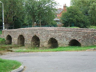
We had lunch at "The Wheel" and then followed the road to a footpath across a meadow with horses on it. We were surprised to notice that the house numbers on the road through Rearsby were nearly up to 2000, which seemed odd for a small village.

The footpath emerged onto the road at East Goscote where we crossed over a bridge over the river Wreake where we watched shoals of fish. Further up the road we passed into some woodland beside a golfcourse. The path was very overgrown and although by the river was not pleasant. The path became very narrow and sloping and encroached by nettles and brambles and there was no wildlife on the river. We eventually emerged on the edge of a large wheatfield. Although there were footpath signs there was no way through the field. A lady with a dog told us if we followed the field boundary we would come to a underpass under the A46. We followed round the edge and under the pass into another wheatfield with a path signpost but a very overgrown field boundary. The proper footpath across the field was missing but a wide track had been put in at a different position. This was full of wild wheat which made the track difficult to walk on. We eventually emerged onto a lane which we crossed and into a field of nearly ripe maize with a good path through the middle. We emerged from this field back at Cossington. 14.8km.

Wednesday 20th August 2008

Rearsby to Rotherby
Back from holiday and off for a real walk! We drove to Rearsby, parked and set off over the pack horse bridge. We headed past the church and then across an area of parkland where two men were repointing an ancient wall. As we crossed the next field we came across a sign saying a footbridge beyond was closed. We decided we should have used the footbridge and needed to look for a diversion. We walked on and met a man, walking his dog, who said work had been carried out on the bridge 6 weeks ago and that it should be ok now. The next man we met told us he didn't know if the bridge was open and then proceeded to direct us on walks all around the area but not appreciating we wanted to stay on the LR. He also warned us about the cows in Frisby who like to chase you - not a good sign for our next walk. We decided to walk on and check the bridge for ourselves and retrace our steps if necessary. We came to the bridge and it looked open so we crossed it. Then over the next bridge and round the corner to find the path taped and warning people from that side that the bridge we had just crossed was unsafe! There was no point turning back now and recrossing the "unsafe" bridge so we ducked under the tape and continued our walk.


We walked across fields and eventually arrived at Hoby where we looked around the church. It had a highly decorated and carved rood screen and beautifully painted ceiling arches.
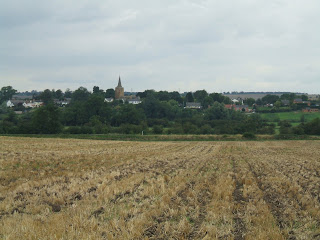
View from Rotherby to Hoby

We went into the Blue Bell for lunch and then walked across more fields to Rotherby. Many of the fields have now been harvested but a few still have standing crops of wheat and barley. From Rotherby we walked along the road and across a cattle grid. Whilst walking across this field John startled a hare who raced away from us, and then we attracted the attention of a large herd of bullocks. We spotted the stile and hastened towards it with the bullocks getting more boisterous and snorting. We quickly got over the stile and relaxed while the bullocksgalred at us from the the side of the fence! We walked through Brooksby agricultural college and followed the track through more fields until we arrived back in Rearsby. 12 km.

Sunday 31 August 2008

Mini Northern tour -Last Stage

Halsall, Southport Friday 15th August to Monday 18th August.
We had a long drive to Halsall, the idea being that it would break our journey home from Edinburgh. The Temporary Holiday site was in a school playground and was run by North West folk group.

Saturday 16th August 2008
As we hadn't done much proper walking over this holiday we decided it was time for a walk. We drove to Formby to do a walk along the coast and parked at a NT car park adjacent to a nature reserve. We walked into the forest and saw several red squirrels. We ended up sitting on a log for about an hour watching them with one coming to within about 3 ft of us. They have had an outbreak of squirrel pox virus in the reserve and the population of squirrels has fallen by about 2/3rds, from 250 but it was lovely watching a few scampering about. We abandoned our walk after that and sat on the beach instead.

Sunday 17th August 2008


It was a bit rainy but we decided to go to Crosby to see the Antony Gormley installation called "Another Place". We parked on the sea front at high tide and could just see a few iron heads sticking out of the water. We walked along the esplanade as the tide was going out and the iron men slowly became more visible. There are about 85 of them along a 3km stretch of coast. We walked to the end of the beach and then back again, stopping at a leisure centre for a cup of coffee.

Mini Northern Tour -Part 3

Edinburgh.
Leaving Beadnell Bay was a bit tricky as several caravans had to be towed off as it had been so wet but John managed to keep going and got to the dry section. We had a steady journey to Edinburgh and arrived after about 2 hours. The site was not so pretty this time being on the Royal Showground next to the airport but did have the advantage of being close to the Park and Ride into Edinburgh and thus another city based break.

Several days were spent walking up and down the Royal Mile, watching street performers and solving clues for geocaches which again led us to some interesting places including a secluded garden and the grave of GreyFriars Bobby.

We had a nice afternoon walking up to Arthurs seat which gave wonderful views across the Firth of Forth.

We were also lucky enough to get tickets for the tattoo which was a good experience.

Saturday 30 August 2008

Mini Northern Tour : Part 2

Part 2: Beadnell Bay, Northumbria

We set off from York and headed towards Beadnell Bay in Northumbria. It was sunny when we arrived but had been very wet so the field was a bit boggy in places. The Temporary Holiday site was about 100 m from the sea, so after some tea we went for a walk on the beach as the sun went down.

Tuesday 5th August 2008
We decided on a walk today as even after all our walks around York city we felt as though we hadn't done a proper walk for ages. We drove to Newton by the Sea and then walked towards the sea and set off along the coast path. We walked beside a golf links and despite getting a little lost we soon found the path towards Embleton and then towards Dunstan Staith where I had a spectacular tumble. I somersaulted down the road ending up sitting in a puddle and having grazed my knee and elbow but luckily had not broken anything. We continued along a farm track passing a war-time pill box which was still in good condition. When we got to Dunstan Staith we turned off the track and headed up the Heughs which was a gorse covered escarpment with good views of Dunstanburgh castle from the top. We followed the top of the Heughs past the war-time radar station towards Craster where we followed the coast path towards Dunstanburgh castle which we looked round using our NT cards. As we were looking round the castle the mist came down and visibility shrunk to about 100m. We could not see the tower on one side of the castle. As we left the castle we found a geocache and then continued along the coast path towards Embleton bay. We walked on the beach back to Newton by Sea.


Friday 8th August 2008

After several days of wet weather where we didn't do much except sit and read in the caravan it finally dried up overnight, so we set off for a walk. We drove to Belford and then walked along the road,down a lane and over a bridge above a very full and fast flowing brook. A field edge footpath was followed past West Hall farm which was like a small castellated castle and towards Swinhoe farm where a lady was giving riding lessons. After the farm we followed the track past Dicks Old Walls (2 stone buildings) and then towards a plantation where we saw a buzzard flying overhead. We followed the perimeter of the plantation with good views to the Cheviots, and we came across some wonderful rock formations called the Singing Hinnies. Whilst looking for a geocache in the Hinnies a RAF fighter flew low and directly overhead. We then continued through the plantation until we came to St Cuthberts cave which was quite impressive.


We walked round and over the cave and through the field beyond to the mound with a cairn on the top. We then followed St Cuthberts Way, through a field with lots of cows, which behaved very well despite making a lot of noise. Our return route was through woodland, seeing lots of chaffinches and yellowhammers. We arrived back at Swinhoe farm and then followed a different route through woods and grassland back to Belford. On the way back to Banburgh we stopped to find a geocache. We walked through a gate, round some rough meadow, climbed a rock outcrop and headed towards some engineering equipment. It turned out to be a wartime bunker and it was possible to go down about 8 m via a ladder to a room below but we chickened out as the hatch lid was a bit rickety and we didn't want to get stuck! We found the cache though.

We finally headed to Seahouses for fish and chips which were eaten sitting on the harbour wall, whilst we watched the tide come in.

Sunday 10th August 2008
It rained all night but was quite bright when we got up so decided on a walk along the coast. We walked towards Beadnell and followed the coast path through a large static caravan park and then onto the dunes. We crossed a narrow bridge over a river and then followed the coast path all the way to Newton by Sea. It was a nice walk across the heath with lots of wild flowers and caterpillars but no sea view. We diverted to walk round the headland and pick up a geocache - and then walked to the pub at Newton, The Ship where we had the best crab sandwiches We've ever had and a couple of pints Dolly Daydream for John and Sandcastles at dawn for me (the pub had its own micro-brewery). There were a couple of bands playing so we sat and listened for an hour and then set off back. We walked back along the coast path but this time after crossing the river we headed down onto the beach and walked along the sand back to Beadnell.

Our mini Northern tour! Part 1


York

Wednesday 30th July - Monday 4th August 2008

We set off on an extend multi-site holiday which started with a Camping and Caravanning Club temporary holiday site at York. The site was on a rugby field which was a 15 minute riverside walk from the city. As we were so close we spent most our stay walking into the city and exploring by doing multi -geocaches which led us to many areas and points of interest that we would not normally have found. One directed us to look for the pig bricks in Swingate, which were quite difficult to spot but once we had our eyes in we found six.


Friday 1st August 2008
We decided on a walk round the city walls which were well preserved and were quite high above the rest of the city giving good views. We had lunch at a coffee house at Walmgate which was an Elizabethan building above the city gate. It was quite nice, full of leather armchairs and a religious library. We finished the wall walk (2miles) and then finished a geocache that we had started yesterday. It was a good walk round and quite fun following in the footsteps of Walter de Gray. Again this walk led us to many places that we would not have spotted - including the area where the Minster stonemasons and lead window manufacturers work.


Monday 21 July 2008

Leicestershire Round Mountsorrel to Cossington

Saturday 19th July 2008
It was sunshine and showers today so we were off to do a bit more of the Leicestershire Round. We drove to Mountsorrel, parked near the butter cross and headed off towards the LR. We crossed a playground and sports field to a stile which according to our 30 year old guide book led beside a farm but now goes through a housing estate. We followed the LR signs through the estate and then followed a path beside a stream. The official LR path was overgrown and impassable but another path ran on the other side of the stream. Signs suggested an alternative route, but an alternative route to what as there was only 1 route under the A6 and in the opposite direction to the LR. After the underpass we retraced our steps on the other side of the stream and eventually regained the LR - quite a diversion. The path now travelled over fields until we crossed the river Soar at Sileby. The heavens opened here, but luckily we had waterproofs.


We followed the path beside the river spotting lots of butterflies (red admirals) and dragonflies; two herons also past overhead. We eventually arrived at Cossington meadows, an old gravel pit which has been left to return to nature. It was lovely, with large ponds, wild flowers and a wide path mown through the middle. There was lots of wildlife including lapwings, swans and coots. We walked through the meadow and emerged in Cossington. Along the village street were several large oak trees which had been planted to commemorate all the coronations since Edward VII. We had lunch in the Royal Oak and then left the LR to return back to Mountsorrel. As we walked along a lane towards an alternative entrance into the meadows we saw two weasels playing in the road.


We followed a different path back through the meadows to Sileby lock, getting another soaking along the way. Here we continued along the river, which was very busy with motor boats and barges.

The river passed under the A6 and returned to Mountsorrel by another lock. It was a very pleasant walk - good job we had our waterproofs.

Thursday 17 July 2008

Yorkshire 9th -15th July 2008

All treatments are finished and so we decided on a well earned break with a week in Yorkshire accompanied by dad! A few walks were planned for this trip but it was also supposed to be a rest and a chance to collect our new walking boots from Altberg in Richmond. We were staying at the Jervaulx Abbey caravan site and dad stayed at the Cover Bridge Inn just a couple of miles up the road.

Thursday 10th July 2008.
We picked up dad from the Cover Bridge Inn at 9:30 am and drove to Richmond to pick up our boots. Dad enjoyed reminiscing about boot making and even the owner of Altberg came out to chat to him. After a few slight alterations to the boots we were on our way.

After a wander around Richmond we drove to Aysgarth to see the falls, they were very impressive after all the rain we have had.

We walked up to the church and saw the rood screen that had been moved there from Jervaulx abbey during the reformation. We then went for a walk on the opposite bank to the one all the tourists use and had nice views of the falls and rapids as we headed along the river to West Burton. As we crossed some fields towards Burton we noticed two follies, one shaped like a cone and the other like a diabolo. They had been built in the 1800's and served no purpose apart from some slight shelter.

We then followed field paths back to Aysgarth. The guidebook said it was a 4 miles walk but we all thought it was more like 6 (actually 5.5).


Saturday 12th July 2008
Dad arrived at about 9.45 and we set off to Studley to see Fountains abbey. We decided on a walk first as it was a bit cloudy and waited for a brief shower of rain to pass and then set off. We walked to the lower car-park and then onto a bridleway beside the old abbey walls. It was very muddy but quite nice with slight views of the abbey. The first problem came around the farm where the footpath went through the yard which was full of cows. They would not move and we couldn't open the gate without letting them out or without getting showered with poo or wee! We eventually found a way round the back of the barn which led into the correct field but which meant wading across a boggy field to get back to the footpath. We then headed through woodland past a ruined arch and onto the Ripon Rowell way. We then followed the path through fields of oilseed rape and wheat and round Markenthwaite Hall. Here we had to cross a field with cows, young calves and a huge bull. He was quite content to ignore us and we quickly moved to the next field where we disturbed several curlews and lapwings. We emerged onto Straint lane, a green lane not wide enough for wheeled traffic and followed the path past barley fields, through to Whitcliffe lane. Here we found we had gone off the path and emerged further up the lane than we should but this cut the road walking down a bit. Next through a field of peas to reach the next stile which led to a water meadow. Unfortunately after yesterday's rain we could not find a way through. Dad got very wet feet trying! We went back over the stile and followed the field edge until we found a low fence that took us into a drier area of the field and back to the path which took us between buildings and back onto Fountains road. We entered the abbey from the bottom entrance and looked at a landscape photographic exhibition. We chatted to the photographer about how he takes his pictures and then walked through the park to the abbey and onto the teashop. After a spot of refreshment we walked back through the gardens with dad taking photos. The walk 11 miles -so much for a restful day!
We left the carpark at 5.15 and pulled into a farm advertising local produce as we wanted some veg. The shop was open but no-one was about. We then noticed the sign saying "self-service". There was an egg box with money and a book to record purchases. What trust. We bought veg and some yorkshire honey.


Sunday 13th July 2008
We decided on a quiet day today and so walked along the river Ure to Coverbridge. The river banks were lovely, full of giant bellflower, meadowsweet, meadow cranesbill and vetches.

There were lots of different types of damselfly too. At the Coverbridge we decided to walk onto the Blue Lion at East Witton where we had a drink and a bag of crisps and then returned along the river to the caravan tohave a cup of tea and slice of cake. We then thought we would walk to the ice-cream parlour. We walked across Jervaulx park but missed the footpath so came out at the wrong place. We eventually found the road and walked up to Brymores. It was packed as mini cooper, motorbike and TVR rallies had all descended on the carpark. We then walked back across Jervaulx park.

Leicestershire Round - Woodhouse Eaves to Mountsorrel

Thursday 4th July 2008
Today we parked in Woodhouse Eaves to do a celebratory Leicestershire round walk as I have finally finished my radiotherapy. The idea was to just walk to the reservoir and back so I wasn't worn out too much. We set off across a good footpath through a field of corn towards a farm and then across a field with a herd of sleepy cows. We then walked through a field of maize until we got to Bunny bridge over the Great Central Railway. We followed the road to Swithland reservoir where we had originally decided to turn round and retrace our steps, however, we decided to continue the walk to Mountsorrel as we were both feeling ok.

Halfway round the reservoir the heavens opened. We managed to stand in the lea of some trees to shelter until the storm passed (about 20 Minutes) and did not get too wet. When the sun came out we continued walking round the reservoir taking care not to tread on the little froglets that were hopping across the wet road. We did pass a lad slopping along in soaking socks, carrying his dripping shoes - he obviously had not been able to find any shelter.

We crossed the road and continued towards Mountsorrel, walking round a quarry and past the castle mound.

We had lunch at "The Swan" whilst another shower passed and afterwards followed the road towards Mountsorrel Quarry where we lost the path and were shown the correct way by a worker. Apparently the bridleway is shown on the map as going through the middle of their weighbridge building. The diverted path took us around the back of the quarry buildings but was not well marked. We dodged the quarry lorries and eventually found the footpath which passed through woodland, until we came back to the road that goes around Swithland reservoir. We retraced our steps and just missed seeing a steam train pass under Bunny bridge- We saw clouds of steam. We walked back across the fields which were a lot wetter than when we had passed earlier. I was exhausted by the time we got back to the car but was pleased to have made it despite having finished radiotherapy yesterday. We walked 14 km.

Friday 13 June 2008

Ashby Wolds Trail

Sunday 8th June 2008

We drove to Measham and set off along the Ashby Wolds trail; a cycle path linking Measham with Moira. It was not too busy considering it was such a nice morning. The trail was lovely and flat and edged with lots of wild flowers.
We followed the trail to Donisthorpe Wood Park which had been a coliary until 1998. It has now been reclaimed and is a lovely woodland.

We continued on the trail and along the Ashby canal to Moira.

There was a canal festival at Moira furnace (a Victorian blast furnace and lime kilns) with Morris dancers and other activities going on.

We passed through and continued along the towpath to Conkers, the National Forest visitor centre. We had been looking for geocaches along the route and had successfully found 6, but the 7th was elusive as we should have got onto the cycle path at Moira but the festival had obstructed the way through, so although we were only 20m from the cache, it was actually about 30m above us on the disused railway line. We abandoned that one and as it had got very warm we retraced our way back along the Ashby Wolds way. We got back to the car after 14.5 km.

Tuesday 3 June 2008

Leicestershire Round - Newtown Linford to Woodhouse Eaves

Saturday 31st May 2008

As the weather was forecast to be good we decided on a LR walk. We drove to Newton Linford and managed to park in the pretty village which had lots of thatched roofed houses.
We walked through Bradgate park which was lovely. We had a lovely view of two fallow deer, with jackdaws sitting on their heads, looking down at us from the cliffs.


We walked through the park to the ruins of Lady Jane Greys house and then set off uphill to Old John.

This was a surprisingly stiff climb and we were all puffed by the time we got to the top. We left the park and walked through Brough wood and then across Lingdale golf course. The course was surprisingly empty but we did see a muntjac deer scampering across the green.

After crossing the golf-course we reached the road and turned right into Woodhouse Eaves. We stopped for lunch (a baguette and Old Peculiar) and then continued walking through the village. The houses were large and very impressive. We arrived in Swithland and then walked through Swithland woods which brought us back to Bradgate Park at the Hall gates entrance and followed the path alongside the reservoir. We were all exhausted by this stage which was surprising as we had managed the 11 mile walk so easily, just 2 weeks ago. The park was very crowded now and we headed straight back to the car. The walk was 14.9km - 9 miles.

Thursday 22 May 2008

Kent Hospices sponsored walk.

Sunday 18th May 2008
Dad, John and I were up early and left home at 8.30 to drive to Charing for the Kent Hospices charity walk. We met friends of dad's (who we were walking with) in the carpark. We set off at 9.30 after getting our walk passports stamped.
There were lots of people walking and we followed a stream of walkers onto the Pilgrims way. We were surrounded by rape fields which affected my eyes so I had to resort to borrowing Brians sunglasses which helped quite a bit. We continued onto the North Downs way and then went to the second checkpoint at Warren Hill where we had a short break for a drink and a hot cross bun.


We continued on to checkpoint 3 which was the almost half way point where we had another short break and then walked along Longreach and the track to Otterden Place. Then onto Stalisfield Green where we had a good sit down and a break at the pub before walking through Kent Wildlife Trust woodland.


It was lovely walking through the woods, there were a few bluebells left but not much wildlife, possibly because of the noise of the walkers sliding through the mud.


We finished the walk at 2.30pm and after getting our passports stamped had a glass of bitter provided by Shepherd Neame. The whole walk was very well organised, soldiers were acting as marshalls at every junction which made it very easy walking as well as drinks and refreshments available at every stop.


It didn't seem like 11 miles, actually it was only 10.5 miles but it still didn't feel like it. We were very pleased that we had completed it and felt so good at the end.

Monday 19 May 2008

Leicestershire Round - Markfield to Newtown Lynford

Tuesday 13th May 2008
We did a LR round walk today in training for our sponsored walk for the Kent hospices on Sunday. It was sunny but with a cool breeze. We drove to Markfield and set off along Main street to reach a footpath which took us under the A50, the path then went through woodland parallel to the A50. It came out into a nice field that had been planted as National Forest in 2000 and gave good views of Bradgate park, where we were heading. We then crossed a large field towards a wood which was filled with bluebells -it was a lovely sea of blue. More National Forest and horse paddocks followed until we reached Newtown Lynford.


We stopped here for some lunch - we were a bit early but sat and waited for the pub to open. We had a nice break out of the sun and then set off again.

We followed the footpath towards the back of Bradgate park where there were lots of people flying kites. Unfortunately the path marked on the map turned out not to be a footpath so we had to alter our route and continue through the park and onto the road. The woods we had planned to walk through also had no public access so we had to walk along the road and find an alternative footpath. We eventually rejoined the LR where we saw a little yellow frog hopping through the grass. After a short stretch retracing our steps, we diverted off onto a different footpath to follow a different return route which brought us to Field Head where we crossed the A50 and returned to Markfield.

The terrain in the last sections of the LR has definitely been new woodland. Leicestershire used to be known as the greenest county in England but with the fewest trees and least access. This has definitely changed with the advent of the National Forest. This area would until recently been full of coal mines and quarries and it is now turning into lovely native woodland. We walked about 7.5 miles.

Monday 12 May 2008

Leicestershire Round -Thornton to Markfield

10th May 2008

Hooray -my chemotherapy is finished and hopefully I can now get back to some decent walking.
We started off by doing a bit more of the Leicestershire Round.
We drove to Thornton, by an interesting route as John was not paying attention! We parked near the pub and set off along the LR and skirted across the top of Thornton reservoir, although the GPS said we were wading through the middle. We then walked through lots of National Forest plantations, mostly planted in 2000 so they were maturing nicely and a great improvement on the spoil tips and coal mines that would have been here before.


We arrived in Markfield and had a drink and bag of crisps at the Bulls Head, where the locals were playing dominos. We then left the LR and walked along lanes and overgrown footpaths towards Cliffe Quarry. We walked around the quarry but did not see any workings although an information board did explain all the geology of the area. There was a lot of gorse in flower on the hills and it was giving off a strong smell of coconut. We walked through Stanton under Bardon behind the houses and then crossed into a field with some cows who were interested but well behaved but a small yappy dog was among them and came charging at us barking furiously.
John eventually roared at it which sent it scarpering away.
We crossed into more National Forest plantations and walked parellel to the same field only to see at the top of the field an enormous bull surrounded by his ladies. I was glad I was now on the other side of the fence.


We continued walking through the plantation to the sound of cuckoos (nothing like yours Judith!!). We finally had to cross a very large field of oil seed rape. Luckily the farmer had cut a good footpath through the middle as it was about 1.5m tall, in full flower and very strongly smelling.

We finally got back to Thornton in time for a welcome drink at the Bricklayers Arms. The walk was only 6.5 miles but had felt much longer as it had been so hot.

Sunday 20 April 2008

Mini-walk

Saturday 19th April 2008

Just a short walk today as we had plumbers visiting this morning! We drove to Ingleby to the John Thompson Inn for lunch and then left the car in the carpark -with permission from the landlord and went for a short walk. We walked along the lane through Ingleby, past lots of lovely houses and cottages and then used the footpath to cross a field, going past sheep, donkeys and llamas. We then followed the path above the river Trent and through lots of coconut scented gorse. The views across the river were wonderful. We stood and watched a heron soaring around for a while and then climbed a very narrow path up over the cliffs and then back down to the river side. The cliffs were triassic conglomerate (sandstone with layers of large pebbles trapped in them). We walked to the caves which were very impressive -apparently a hermit lived in them, they were very large with big columns inside.


We retraced our steps to the pub. It was only about 4km but a pleasant and interesting walk.

Wednesday 9 April 2008

Leicestershire Round - Nailstone to Thornton

Thursday 3rd April 2008
We did a Leicestershire Round walk today. We had originally planned to walk to Thornton but following our colds and lack of walking we thought we might cut it short at Bagworth. We parked at Nailstone and followed the path to Bagworth. This had been coalmining country and our 25 year old guide book warned us about the spoil heaps and quarrying, but the pits had closed and the land is now reclaimed and planted with trees as part of the new National Forest. We arrived in Bagworth quite quickly but could not see anywhere to stop for lunch so decided to walk on to Thornton on our original planned route. We had lunch in the Bricklayers arms which we had visited a few weeks ago. The same group of old men were in there putting the world to rights and discussing the old railways through Bagworth and the history of the Swannington incline which was quite interesting. We walked on after lunch and lost our way a bit around the Thornton brick works but eventually found the route passing by some fishing lakes. We came out onto the road to Barleston and were stopped by a chap who asked us if we were heading onto the footpath across his land. He had had a run-in with gypsies that morning who had been stealing stuff from his stables. He had had stiches and was still bleeding from the assault. He said he had cameras filming so we might be filmed. He spoke to us for quite a while telling us tales of shooting arrows at night and jogging across his land naked carrying an axe to cut down a tree in the early morning and wondering why the birdwatcher ran off leaving all his equipment behind! We had quite a laugh, I think he was a still shaken from his experiences that morning and wanted someone to talk to. He said if we were back that way in the summer to call in for a glass of wine! We continued across the fields towards Barlestone and along a river bank and then set off on a footpath back to Nailstone.

We were stopped by another local who told us we had missed the footpath and pointed out the correct way. He stood chatting to us for about 15 minutes telling us about all the local walks. We finished off the walk and got back to Nailstone at about 5.30 after 16 km. So much for a shortened walk but it was nice having chatted to so many friendly locals.

Friday 28 March 2008

Dover -14th March 2008

Friday 14th March 2008


We decided to celebrate Easter early before my fourth chemo session so travelled to Kent for the weekend to do family visits.


On Friday it was dry when we got up so despite the forecast rain we decided to go for a walk. Dad drove us to Dover and we parked by the NT visitor centre. We then walked along the cliffs to St Margaret's bay. It was quite slippery in places, dad slid down a bank at one time (luckily nowhere near the edge of the cliff) and we had to haul him up and find another route round.


The sun came out and it was lovely looking at the cliffs and the ferries arriving from France. The SeaFrance strike meant that several of the ferry bays were empty which was unusual but there were loads of lorries queued up waiting for crossings.


At St Margaret's we stopped at the Coastguard for a drink and then walked back along the same route. The gorse was in flower and there were lots of rabbits about.

At the South Foreland lighthouse there was a sign out showing it was open, for the first time this year, so we went in and had a quided tour. Several landmarks were pointed out from the top including the WWII radar staions (originally 4 now only 3), the house where Ian Fleming wrote the first 007 book -apparently the local bus number was 007! and finally the house overlooking the cliff owned by an American who insisted on flying the Stars and Stripes when in residense so that the first thing travellers saw when arriving at Dover was an American flag! The lighthouse was clockwork powered and we got to wind it up so that the top was turning -great fun. We continued the walk back to the visitor centre and had a cup of tea before driving home. A really nice day and our first real walk for ages! (10km walked).

Friday 29 February 2008

Yorkshire

17th February - 24th February 2008


I am into the third week of my second chemotherapy treatment and as I am feeling fine we decided to take advantage and head off to Yorkshire for a few days. We took the caravan to Jervaulx Abbey caravan site which is a caravan club cl which holds 5 caravans and is very peaceful. We set the van up and headed off for a short stroll around the abbey.
18th February 2008
After a very cold night we discoverred that everything was frozen. We had no water so could not have a shower. It started to defrost by about 11 and we then found that the drains were frozen so nothing would drain away. We decided to move the caravan down the field where we weren't in the shadow of the wall and it got the sun earlier. We wound the legs up and John moved the caravan on the mover. I moved everything else. We then went for a walk. We crossed the road and then walked down to the river Ure. It was a lovely walk along the river bank which was covered in snowdrops. The sun was bright and warm. We arrived at the Cover bridge Inn where we stopped for lunch. We had a cold meat salad and a very nice glass of Old Peculiar. The pub was warm and cosy with a roaring log fire and it was an effort to move on but we eventually left and walked along the river Cover which was bubbling over limestone pavements and was lined with icicles along the bank. We crossed the bridge and walked down the other side of the river until we reached East Witton. We then crossed fields and returned to the Cover Bridge and followed the river back to the caravan. About 13 km.

19th February 2008

A very foggy and cold day today and the water pipes were still frozen so we set off to Richmond to order some new walking boots. They will be ready in May. We spent the rest of the day wandering around Richmond. The castle was closed so we couldn't go in but we walked round the walls and enjoyed the views -albeit through the fog!

Wednesday 20th February 2008
Freezing fog today, it looked beautiful out - sunny but so frosty it looked like snow. We drove to Thornton Steward Reservoir along lovely frost covered lanes. We walked along the side of the reservoir and then onto the bridleway. We found a geocache near the end of the reservoir. The frost was falling off the trees as we passed. We followed the bridleway to Finghall where we were met by a large barking doberman, but luckily he just walked past us. We had a nice lunch at the Queens Head and then walked down the lane and across fields beside a stream and across the Wensleydale railway. It was lovely and sunny. We found Drews mistle -our second cache which had a travel bug and a useful shoehorn! We passed the 12th century St Andrews church and walked through a large caravan park, across the golfcourse and back across the railway. The footpaths were not well marked here and it was difficult to work out where we were going and ended up the wrong side of a spinney and farm house but we found the path at the top and managed to cross the fence! We then followed the path round fields and through small woods where we saw several hares running across the fields. We passed a large group of boys who were out for a walk and then emerged near Aysgarth school which was a very posh looking school, complete with castleated tower. We followed the track, picking up another geocache on the way, hidden in a tree stump and picked up a geocoin and 2 dvds. At the end of the track we walked along roads for a while and then back onto a footpath where they were renovating two cottages. They had completely blocked the footpath and we had to find our way into the wood and follow the gps through as there was no obvious path. We emerged at the footpath sign so must have followed the right route. The rest of the walk was across fields and muddy tracks (where Yorkshire water were laying new mains water pipelines) and the road back to the car. 15 km. We got back to the caravan to find everything melted and working. We had tea and a welcome shower. We watched Notorious - -a Hitchcock dvd that we had picked up in Nook and Cranny geocache. Lets say they don't make them like that anymore! It will be recycled in the next geocache we find.


Thursday 21st February 2008
Whoopee, no frost today, it has been replaced by rain and strong winds! We pottered all morning and then drove towards Masham along very scenic windy roads - meaning narrow and steep. We went to a forest area and visited The Druids Circle - another place we wouldn't have found if I hadn't searched for geocaches in the area. The circle was fascinating, based on Stonehenge but built by the Victorians to provide work for local men. We followed the gps into the forest and found the geocache. It had been unvisited since october but was still dry. John took an interesting "american free iraq" coin. It was very cold and windy so we retraced our steps to the car. We drove into Masham and parked and then strolled to the market place. We bought some boar sausages for tea. We then had a wander round the town solving the clues for Masham march (another geocache). We went into the church which had lovely stain glass windows and a painting attributed to Joshua Reynolds. We had tea and baguette at "Mad Hatters tea shop" and then did a little shopping. Just a couple of short strolls today!


Friday 22nd February

After a very noisy and windy night it was slightly calmer today. We weren't sure what to do but in the end drove back to Richmond for another look round and to finish the geocaches. We walked to the top of the town and had views across to the castle then walked along the river to solve the last clue. The waterfalls were very dramatic. We then did another cache which was on the other side of the river. Finally we went for a drive along a lane for about 2 miles to the Richmond beacon. It was pouring with rain and blowing a gale. During a break in the rain we set off up the hill to the beacon. Halfway there the rain started again, it was freezing. We were both frozen and soaked when we got back to the car.

Saturday 23rd February

It was a bit dismal today but Emily and Mike were coming to visit but they didn't arrive until 1.30 because they got caught in the Middleham diversion. We went straight out to the Coverbridge Inn for lunch which turned out to be enormous. We had ham and eggs which must have been about a 16oz gammon. We got back to the caravan at about 3 and had a cup of tea. Then went for a short walk round the Abbey. It started to rain so we went back for another tea and they left at 6.30.